The perfect app for precipitation and storms. Real-time radar data for rain, snow and hail, Weather Analysis LiveHD, tornado doppler radar, as well as lightning and storm tracks. High resolution precipitation forecast for up to 24 hours. With life weather observations by the user community and a huge archive for all measurement data including lightning for all of the data which covers Germany, Austria, Switzerland, Liechtenstein South Tyrol (The Alto Adige region of Italy) and Luxembourg.

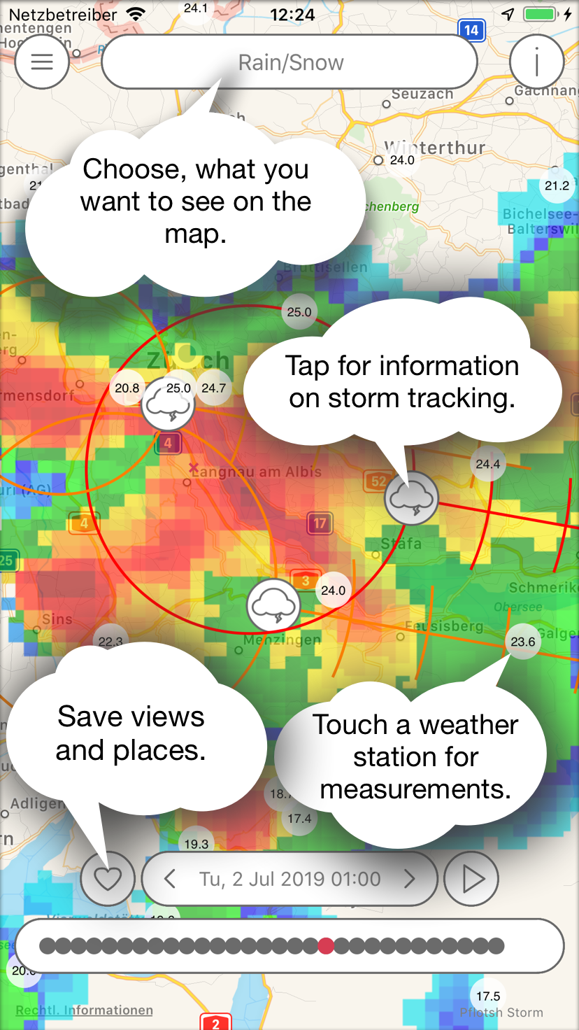
The app shows areas of precipitation and severe weather with an update cycle of 5 minutes and forecasts shower and storm centers and their movement.

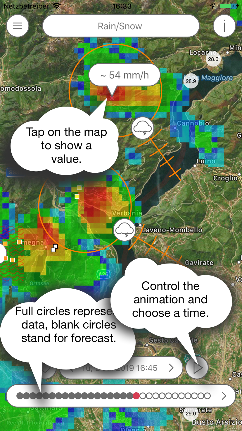
The radar forecast is provided by extrapolation of the actual echoes to forecast 1 hour ahead, then a 3x3 km resolution model which is being updated every 3 hours takes over for the forecast period between 1 and 24 hours in the future.

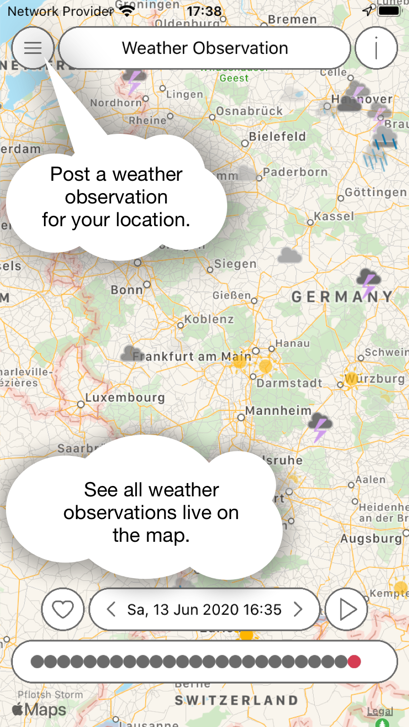
Weather observations by the user community are displayed live on the map. They disappear after two hours. By moving in time, you can see all messages that have been made in the past.

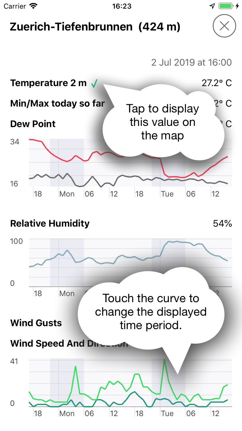
The map shows current readings of weather stations. If you tap on it, the measurement values are displayed over the past 24 hours.
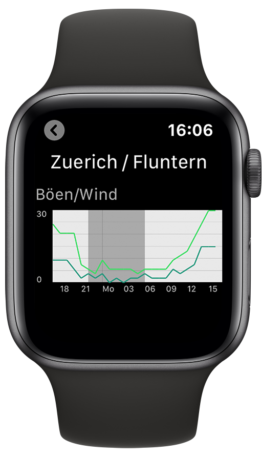
Apple Watch App

The Storm Apple Watch app shows the readings for a selected weather station.

bild

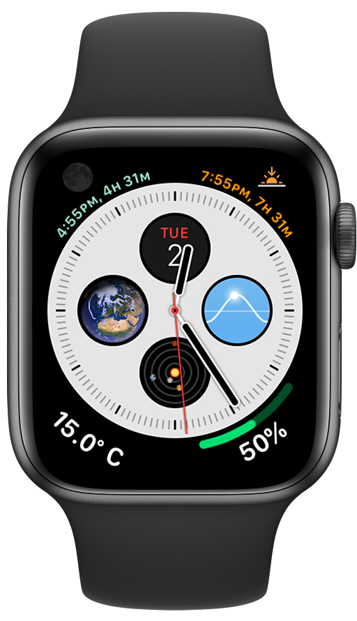
The complication shows the temperature. In bigger complications, the minimum and maximum (since midnight) are also shown.

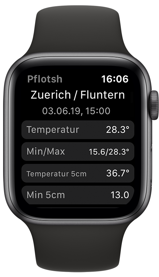
Depending on the weather station, different values are displayed.

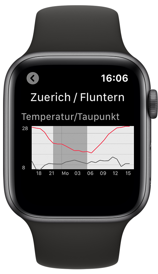
A tap on a line leads to a detailed view.

Weather stations can be added to the Apple Watch on the iPhone. Then you can use Force Touch to select which of them will be shown.

Jörg Kachelmannexplains what Pflotsh Storm can do. In German.

Jörg Kachelmannexplains what Pflotsh Storm can do. In Swiss German.

Download


Subscription

In order to cover the cost for the data and the further development of the app there is yearly amount to be paid via subscription. The first month is free and you can cancel the subscription without being charged during the first month of use. Buying a Pflotsh ECMWF subscription also unlocks to all other Pflotsh apps, if they are installed on the same device.

Take a look at the subscription information.

Q&A

1. How can Pflotsh storm help me?

The app protects from severe weather surprises, gives you radar and lightning information for your area and a radar forecast for the next 24 hours.

2. Why there are several Pflotsh apps and not just one?

The various apps are focussed on specific purposes. They have different functionalities, and contain a different selection of weather parameters and models. If all apps were combined to one single app, that one would be rather confusing with too many options getting into the user's way. The individual apps each show exactly what is required for a specific purpose. See all Pflotsh apps at a glance.

3. Where does the weather data come from?

Radar data is from the National weather services involved, lightning data from various sources, forecast from Kachelmann GmbH and the DWD.

4. How accurate are the data?

Radar resolution is between 250 m and 1 km, lightning strikes are mostly within a 100 m radius. Model forecast is from a 3x3 km model which is being run every 3 hours.

5. Who provides the forecasts?

Kachelmann GmbH is source for the radar forecast up to 1 hour and the storm tracking, the model forecast comes from the DWD.

6. How accurate is the radar forecast for the upcoming hour?

For this purpose, the radar echoes are being extrapolated. There is no calculation of weakening or strengthening nor for new echoes in the algorithm. Those are being handled by the high update frequency of 5 minutes. Please note the the most recent radar image for Austria (except Vorarlberg which is covered by the Swiss radar) is a 5-minute-forecast from the previous radar image since the Austrian provider doesn’t allow the display of up-to-date radar imagery.

7. How far does the model radar forecast take me?

The model radar forecast is run for the next 21 to 24 hours.

8. Why are maps always the main view in the all Pflotsh apps?

A weather map provides a lot more information than weather data for just one location. E.g: If you want to take a picture of a mountain, it is not important if the sky above you is cloudless, you want to know if the subject is hidden in fog. And anyone who is on the move wants to know how the weather is developing along the way.

9. While I am panning or zooming, the data is not shown. Why?

In order to see the map. Data is drawn with little transparency, so that it is visible well and without interference with the map. However, in some cases, you won’t see the map well enough. In those cases, just pan.

10. Why do I only see a map?

Either there is no rain in your area and you can check back past events via the archive function (star icon). There is also the unlikely possibility that one of the radar stations is down.

11. What do the small numbers in the circles mean?

These are measured values of weather stations. By default, the temperature is displayed on the map at the selected time. If a measuring station is tapped, all currently available readings of the selected station are displayed. These also as graphs for the past 24 hours.

12. Why are measurements missing at some weather stations?

Not every weather stations are equipped to deliver all values. Also, the weather stations provide their data at different times and at different intervals.

13. Can an other value than the temperature be shown on the map?

Tap any title, for example, wind gust. If you can see that the green check mark is next to it, the selected reading will be displayed on the map.

14. What are the orange and red circles for, and what do the ladder-like strokes stand for?

When a thunderstorm is detected, a circle appears around the storm cell. You can use the line to see which direction the storm is going. Small dashes indicate the position of the storm in 10-minute increments.
You can tap on one of cloud-icons icons to get more information about a particular storm cell. This shows radar data, lightning data, as well as information about the intensity of storm cells and their forecast paths. This data is derived from extrapolating the storm’s current speed and direction and thus may not always be precise, should the storm change speed or direction.

15. What do those rings with the arrows mean?

They show the direction and strength of the rotation of a storm cell. They only appear when a storm actual has a rotation.


16. What do the ripples mean?

If there is a risk of flooding, the wavy lines indicate flood areas.


17. How do I toggle between map and satellite view?

Go to the menu and touch "Settings". You can then customize the map type.

18. How do I choose the date and time which I need information for?

Please tap on the date display in the center and choose date and time and confirm your choice via check mark. You can also tap the arrows to the left (to the past) or right (to the future). See also Timeline in Tips and Tricks.

19. How do I get immediately to the present time and my place?

Shake your phone! This also updates the data. Alternatively, select the corresponding item from the menu.

20. How do I update the data for the place I am currently seeing?

Long press the date display. Alternatively, select the corresponding item from the menu.

21. Can I get a radar forecast or storm tracking for any other place than mine?

Yes, just move the map with your fingers and get to any place in the target areas Germany, Switzerland, Austria, Luxembourg, Liechtenstein and South Tyrol.

22. What to do if I cannot see my own position or something else on the map clearly?

Move two fingers to the left or right on the time display at the bottom of the screen. This changes the transparency (see also Transparency) in Tips and Tricks.

23. Why is there no legend to the colours and icons?

You won’t need that, just get all your info by tapping on the screen (see also Information about Colors).

24. Why does the app say "No data available"?

The map has been moved to an area outside of the covered area.

25. Why are the lightning icons flashing?

These are the most recent lightning strikes from the last 5 minutes, the older they get, they turn yellow, orange.

26. Why don’t I see any lightning strikes?

Only lightning strikes during the last 30 minutes are being displayed.

27. Why do I see pixels?

You get the max resolution of the radar, so the closer you get, the more likely you are to get pixels which have a size of about 250 m to 1 km on one side. Tap on the radar pixel to see the corresponding intensity of precipitation.

28. If I activate Meteosafe push messages, which kinds of messages can I see within the app?

The app receives push messages according to the account settings on meteosafe.com. However, only messages related to the contents of the app are pushed: Thunderstorms/Heavy rain, torrentials, lightning strikes, hail, cyclones, and aquaplaning. This means that, for example, for frost, you will only receive an email, but no push message.

29. Why do I see hail if there is no precipitation?

The app shows the sum of all hail since midnight (UTC) and not the current hail amount.

30. How do I add the Pflotsh Storm radar widget on my iPhone?

Swipe to your Lock screen and tap "Edit." (see also Widgets for the iPhone in Tipps und Tricks)

31. Which operating systems work with Pflotsh storm?

It works from iPhone 5 or iPad from iOS 10.0 or higher, Android from version 4.4 (KitKat).

32. How do I pay for the app?

In order to cover the cost for the data and the further development of the app there is yearly amount to be paid via subscription. The first month is free and you can cancel the subscription without being charged during the first month of use. Buying a Pflotsh ECMWF subscription also unlocks to all other Pflotsh apps, if they are installed on the same device.

33. What can't the app do for you?

This app is not intended to replace official warnings by the National Weather Services of the countries involved, but it is a perfect supplement if you want to assess the weather situation for yourself.

Apple Watch App Q&A

1. How do I install Pflotsh Storm on my Apple Watch?

Use the "Watch" app on your iPhone. Under "My Watch", Pflotsh SuperHD can be selected in the "Available Apps" segment. Pflotsh SuperHD will be installed on your Apple Watch.

2. How can I add the Pflotsh Storm complication?

In the app "Watch" the watchface can be configured. On your Apple Watch, force touch on the watchface to enter customization mode. The parts of the watchface ar now outlined in green. Select a complication. Rotate the Digital Crown and scroll through complications to select Pflotsh Storm.

3. I scroll through all the avalable complications, but Pflotsh Storm does not appear.

Not every watchface has space for complications. Complications have different sizes. Choose a complication of an appropriate size to display a Pflotsh Storm value. Choose a small complication.

4. How can I select a weather station for the Apple Watch?

Make sure that the Pflotsh Storm app is active and displayed in the foreground on your watch. Then, in the Pflotsh Storm app on your iPhone, tap on any weather station. Make sure the app is visible on the Watch. On the iPhone, scroll down and select "Show on Watch". Caution: "Show on Watch" only works while the Pflotsh Storm app is visibly displayed on your Watch.


Share this link on Twitter, or on Facebook.


Follow us on Twitter@pflotsh, or send us an email support@pflotsh.com. We are looking forward to your feedback.